How to use Atoll RF Planning Tool
Introduction
An Atoll is a detailed multi-technology (2G, 3G, 4G and 5G) RF network planning and optimization software that supports service providers throughout the network lifecycle, from initial network design to meet capacity increase and further optimization.
Atoll Tool Capabilities
Multi-technology Network Planning
- Atoll tool supports multi-technology network planning starting from GSM/UMTS/LTE till latest 5G NR.
Prediction and Measurement-based Planning and Optimization
- Atoll offers unique capabilities of using both predictions and live network data throughout the network planning and optimization process.
- Live-network data real-world information and allow for a better coverage and quality evolution, identifying hot-spots, and tuning propagation data. Live-network data can be also used to drive the planning process (small cell selection) and to steer the optimization algorithms of the AFP and the ACP.
High Performance Geographic Information System
- Atoll incorporates a high-performance built-in geographic information system (GIS) specially designed for RF network planning and optimization.
- Atoll’s GIS engine allows working with high-resolution and large-scale geo data while delivering high performance in data manipulation and display.
- Atoll supports web map services, online maps (Bing, google, etc.), and standard formats including BIL, KML,KMZ, BMP, MapInfo, etc.
How to work with Atoll
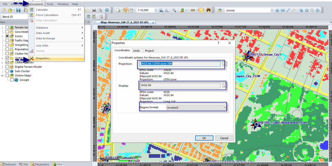
Setting Co-ordinate System
Co-ordinate System helps to import and plot the GIS Map data in proper format and align with the lat long information. It is under Document —> Properties —> Coordinates.
Importing GIS Map Data
In RF network planning GIS data is very important, it includes Clutter, Terrain , Vector Maps.
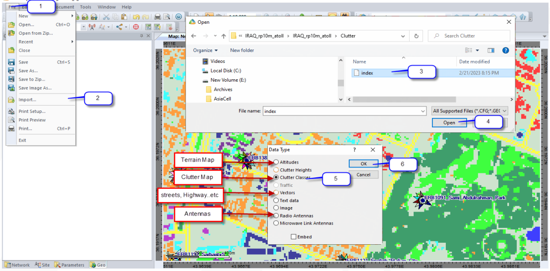
In Geo Explorer many maps, some of them are mandatory in prediction process such Clutter Classes and MDT maps others are just helpful in visualize the area that working on such google online map and Vectors maps which represent streets, highway, river and etc.
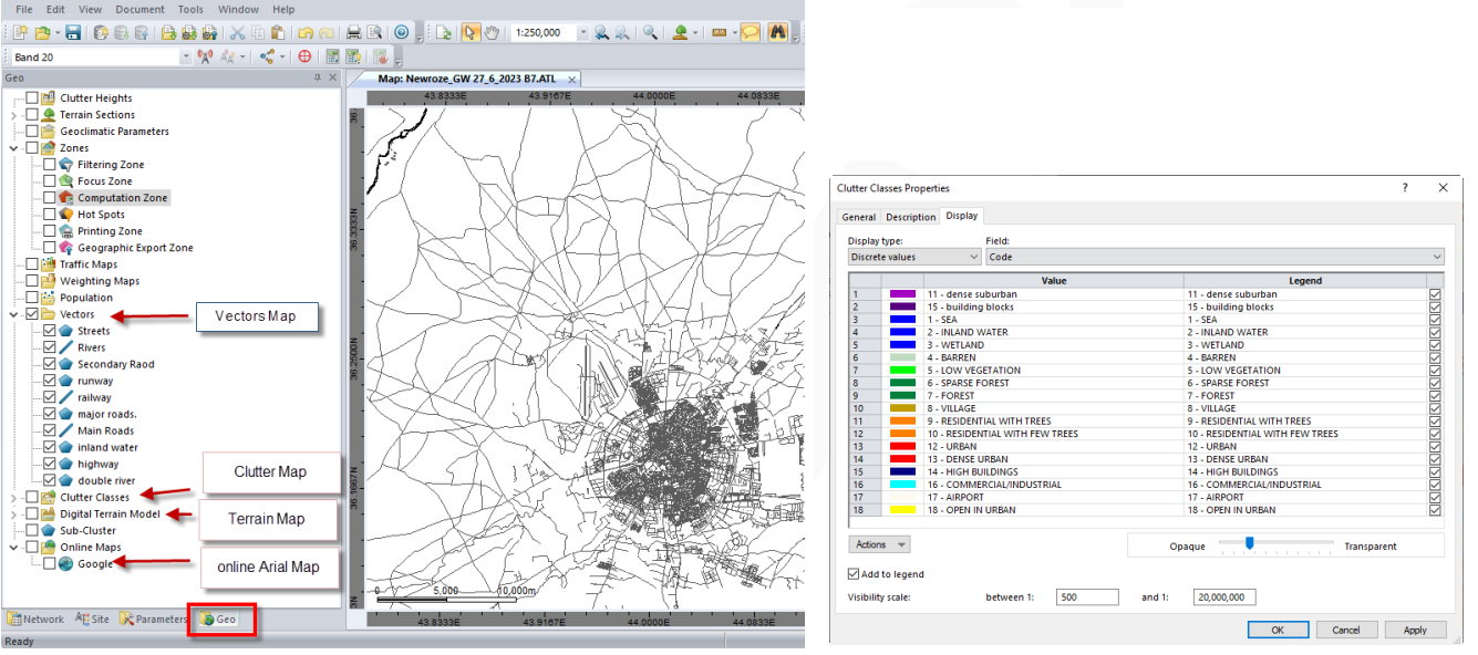
- Clutter Map represent the the clutter types per segment, Hight resolution Map contains high number of small segments with 10m or 20m square area. Its mandatory to predict the indoor loss introduce by clutters
- Terrain Map or DTM ( digital Terrain Map) represent the land profile ( land elevations ) its too important to predict the signal reflection or blocking by the land.
Setting Propagation Model
Propagation Model is series of mathematical equations to calculate the signal propagation and strength
these equations include many constants and variables need to be set in parameters tap also need to set up the indoor losses per each clutter class . Standard Propagation Module (SPM) Suburban/ Rural is more reliable.

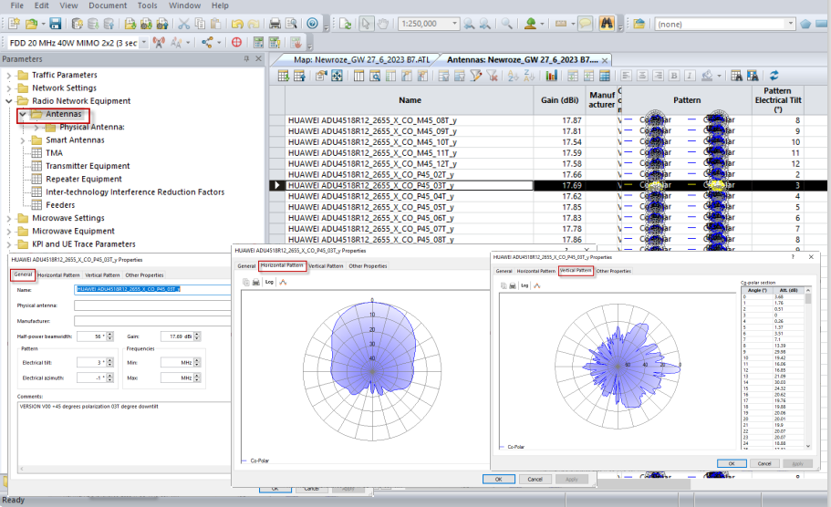
Configuring or Importing Antenna Patterns
Each Antennas type need to be represented in the Atoll platform using module provide Radiation beam simulate the real beam radiated by the existing antenna also include Gain, Half power beam width , VSWR and other variables that affect transmitting electromagnetic wave.
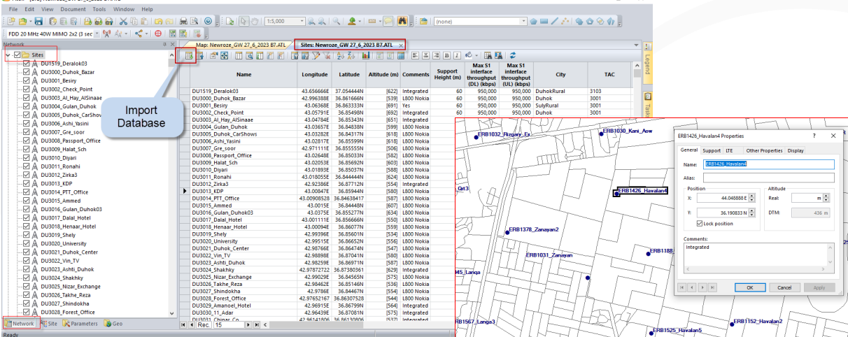
Site, Transmitter and Cell Creation
Sites are the first Network elements need to be created then other elements like Transmitters and cells can be created. Database of the network sites can be set in CSV file then imported it to Sites table.
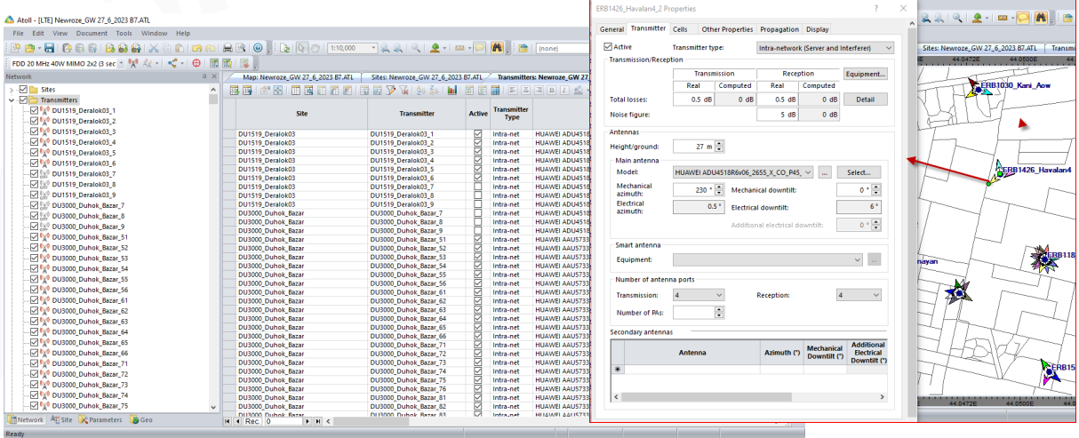
Transmitters include the physical parameters for the sectors / cells like height, azimuth, M tilt , propagation module also include Antenna modules which contains Etilt also it could contains extra information not affect the prediction and helped in analysis such TAC id.
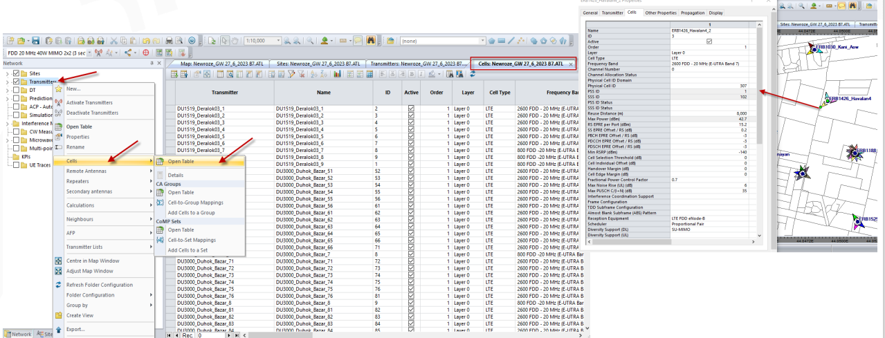
Cell Creation
Cells can be created after Transmitters set the are include the logic parameters like PCI, RSI, band also RS power setting and etc .
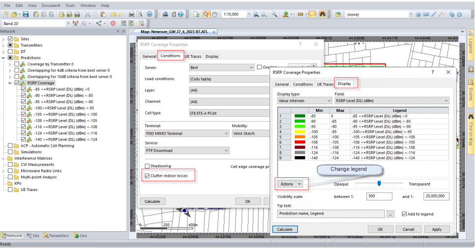
Running Prediction
Prediction is the most important function Atoll. In prediction can be for Coverage and Traffic Coverage parameters prediction is most accurate simulation more than Traffic prediction which depend on may settings such mobility strategy and user behavior etc.
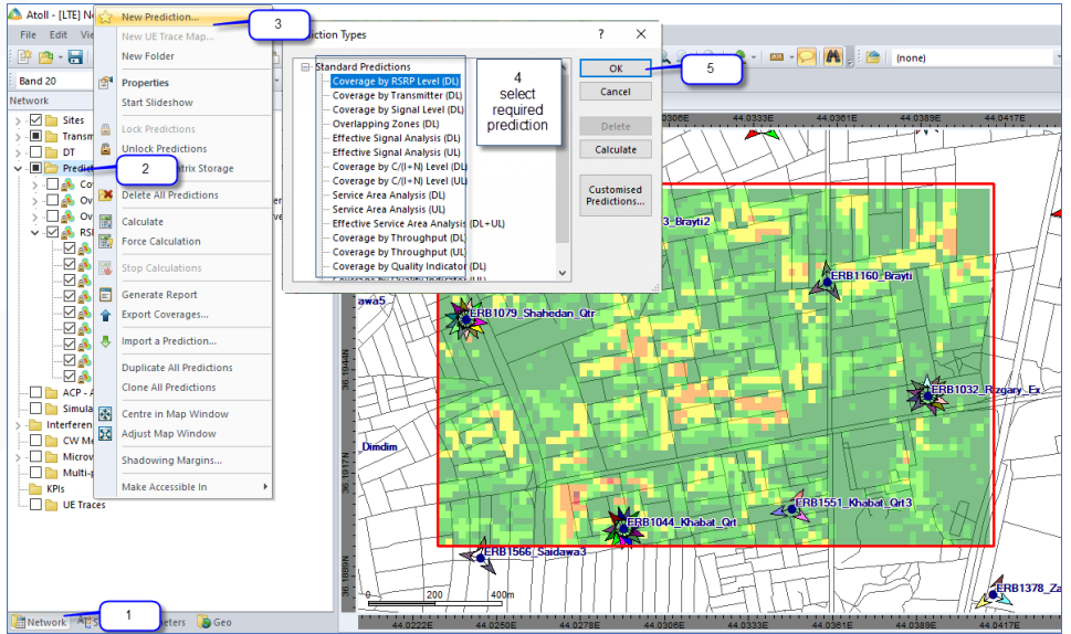
Prediction Setting
It is important to select indoor losses or not Also to modify and reach the required legend
Related Post
- RF Planning – Standard Propagation Model Tuning in Atoll
- 50 + Top RF Planning and Optimization Interview Question
- 5G Network RF Planning – Link Budget Basics
- 5G mm Wave 28GHz Band Link Budget-n257
References